Quantcast
Channel: Bentley Communities
Viewing all 135 articles
Browse latest View live

gINT Can: Change Grid Data Entry Layout

$
0
0

Layout of tables, fields and records is easily changed in the Input application, to tailor the grid data-entry screen for easy input.

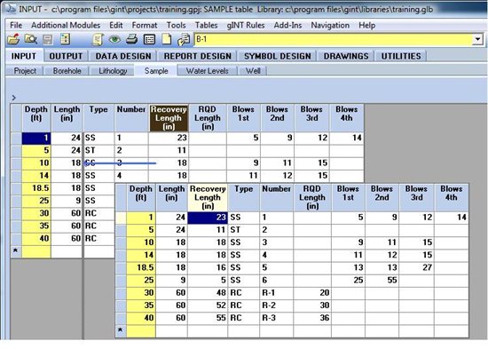
With a few restrictions, the order of fields can easily be changed by dragging the column header right or left. This does not affect reporting of data stored in the field, because gINT does not use field order to locate data.

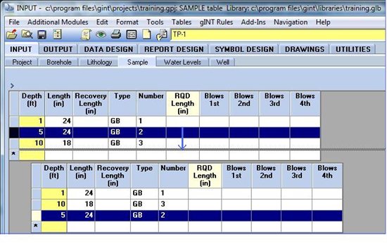
Record order can also be changed by right-click-and-dragging the left-most cell in the row up or down:


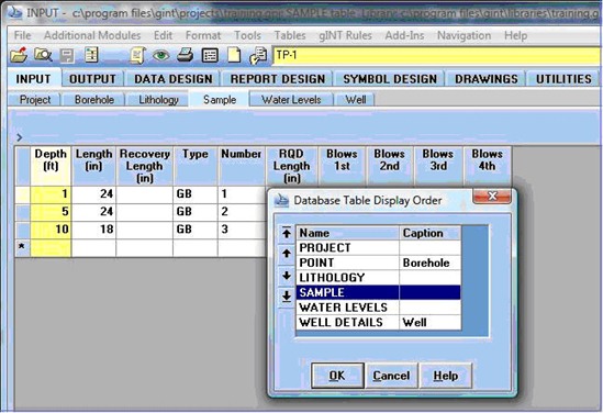
You can change the order in which tables are displayed in the grid data-entry screen:

With these tools, it is easy to configure the data-entry grid for efficient input.

References - Help Topics
- For information on moving columns and rows, see gINT Help > Contents > Input Application Group > Grids
- Changing table display order is covered in gINT Help > Contents > Commands > Alphabetical List > Input Sequence.


Pat Cummings
gINT Trainer


gINT: Geotechnical Software for the way you work!

$
0
0

On December 8, 2011 Bentley hosted an eSeminar about gINT software titled "Geotechnical Software for the way you work!". It addressed new features of gINT v8i SS1 which was released December 9, 2011.

During this seminar, the latest tools enabling you to export boreholes as 3D cylinders in MicroStation, export DTMs based on gINT subsurface data to LandXML, and apply user-defined coordinate systems were introduced.

Throughout the eSeminar attendees were able to type in questions. As many as possible were addressed during the eSeminar. Due to time constraints, several questions were not addressed.

This post is a summary of the questions asked and their answers. A few questions were asked more than once in different ways. These questions were consolidated.

Also, a fair attempt to break the questions in to categories was made. Categories include: Modeling/CAD Environment, gINT Capabilities and Features, and Other.

Modeling/CAD Environment

1) Can cross sections be cut in the DGN file?

Answer: Yes. If you need a series of sections along a reference line or alignment, a Bentley civil package such as GEOPAK, InRoads or MXROAD will be required. If you are looking to create a single cross section through a particular section then you can use MicroStation's dynamic section capabilities.

2) Can you draw cross sections through the created XML surfaces

Answer: Yes

3) Is there any planned integration between the gINT software and the GEOPAK Geotechnical tools?

Answer: GEOPAK and gINT are both Bentley solutions. Integration and working together to create a better solution is a long-term objective. Currently gINT does export borehole data in to a format which can be imported in to GEOPAK and used with the Geotechnical Tools.

4) Can GEOPAK model slope failure?

Answer: No, GEOPAK does not model slope failure. However, Bentley is the third party reseller for GeoStructural Analysis which includes a slope failure evaluation module.

5) Is GEOPAK just a drawing product software or does it perform modeling/strength calculations too?

Answer: GEOPAK is a civil design modeling application widely used for transportation projects. It cannot perform engineering analyses.

6) Can we use InRoads instead of GEOPAK?

Answer: Yes

7) Will we be able to import a gINT database in to GEOPAK Geotechnical Tools?

Answer: There already exists an Export to GEOPAK feature in gINT such that the data exported is used by the GEOPAK Geotechnical Tools. gINT Help provides details to executing the export feature.

8) Can AutoCAD Civil 3D read the i-model DGN files and DTMs?

Answer: AutoCAD 3D cannot read the i-model DGN files. DTMs are XML files (that is, the "DTM to LANDXML" export function in gINT exports the files as XML files). These files can be read by any application that is capable of reading XML files.

9) Is there a way to view the boreholes in 3D using AutoCAD civil 3D or ArcGIS instead of MicroStation.

Answer: No. For AutoCAD and ArcGIS products only 2D views are possible after export of data from gINT.

10) Is there a plan to provide an export to AutoCAD in the near future?

Answer: There is a 2D AutoCAD export in gINT available at this time. gINT does also export reports to DXF format. For a 2D export to DXF format in gINT go to teh Output tab and select File => Export to File =>AutoCAD (DXF) File.

11) Will gINT be compatible with AutoCAD and perform similar features to those you've shown on MicroStation in the near future?

Answer: At this time the i-model features can only be read by Bentley products. LANDXML files are an industry standard which can be read by many applications.

12) Will a DXF exported database which is opened by AutoCAD be able to do volume calculations based on the lithology?

Answer: From gINT, DXF exports are limited to reports such as logs and fences. At this time data from the gINT database cannot be exported into DXF format to be read by and CAD application. Data can be exported from gINT v8i SS1 in XML format to be imported by CAD applications. With the current version of MicroStation (v8i SS2) all volume calculations are performed with a civil solution which overlays MicroStation such as GEOPAK, InRoads or MXROADS.

13) Is labeling of the 3D boreholes done in gINT or MicroStation?

Answer: gINT

14) Can the gINT labeling be edited in MicroStation?

Answer: The i-model is not able to be edited, including the labeling exported from gINT.

15) Can you upload a 3D model scan of the area where the soil borings were taken? In MicroStation you imported a 2D sitemap, could you upload a 3D terrain model?

Answer: Yes

16) We have MicroStation v8i Select Series 2. Will MicroStation v8i Select Series 2 still work with gINT v8i Select Series 1?

Answer: gINT v8i will continue to work with MicroStation v8i Select Series 2 as before. gINT v8i Select Series 1 has the enhanced capabilities of exporting i-models and Digital Terrain Models (DTMs). Referencing in the i-model can be done with MicroStation v8i SS2. Digital Terrain Model (DTM) work was performed with GEOPAK - a civil modeling overlay to MicroStation. MicroStation SS3 (anticipated release spring 2012) will be able to import DTMs without a civil engineering package such as GEOPAK or InRoads.

17) Is the scaling of the borehole width and length automatic when imported MicroStation on cross sections?

Answer: The scaling for the boreholes is automatic when imported in to MicroStation. gINT requires a field for the borehole radius, so you have control over the radius.

gINT Capabilities and Features

1) I don't have the specs for gINT, what is it generally? Is it a separate, stand alone software that works within  or outside MicroStation?

Answer: gINT is a standalone, geotechnical data management tool. Inside of gINT you can create several reports including borehole logs, fences, and graphs. gINT also exports and imports all geotechnical data which enables it to work with other software applications such as MicroStation, GEOPAK and Excel, for advances analysis and design. For additional information about gINT please refer to the gINT webpage.

2) Not related to the presentation topics, but is there a way to input pile load test data into gINT?

Answer: At this time gINT does not include a standard template for pile data. However, you can add one if you like, Bentley Professional Services can also assist you with development. gINT does not typically analyze pile data at this time - it would only store your geotechnical data in a single location for you. As an aside, Bentley has another application, GeoStructural Analysis, which has a pile analysis module.

3) Do I understand that if one types in the latitude and longitude, gINT will calculate the northing and easting?

Answer: Yes, this coordinate conversion occurs within the gINT Professional Plus product.

4) What are the possibilities in gINT to have environmental lab results and display them in a customized table/sheet?

Answer:gINT is a fully customizable database. It is possible to add tables for Environmental lab results and display them on customized tables/sheets.

5) Can gINT also model groundwater data from boreholes?

Answer: gINT can produce depth over time plots for groundwater measurements. Also, groundwater elevations recorded can be plotted on a fence or log. However, groundwater profiles cannot be created in gINT.

6) We are using two versions of gINT: v8 and v8i. Will these o-model and DTM to XML features work with both versions of gINT or just v8i?

Answer: These features are available in gINT v8i SS1, which was released on December 9, 2011.

7) What type of database is gINT using?

Answer: gINT Logs and gINT Professional use a Microsoft Access database. gINT Professional Plus uses a SQL server database.

8) How do you plot borehole information on a profile?

Answer: You can plot borehole information in a profile format using gINT fences. If you want to plot along a roadway alignment, then you can use GEOPAK or InRoads, or you can use the alignment option in gINT to define a specific alignment and create a profile along the alignment.

9) We are using gINT 08.30.02.39, and we are a Bentley Select ELS customer. Is the version available tomorrow (December 9, 2011) available to me with no additional cost?

Answer: If you are a current Bentley Select ELS customer or you have a current Bentley Select agreement then you can download the new version of gINT at no additional fee until your Select agreement lapses.

10) Will gINT be integrated with ProjectWise and MicroStation in SS3?

Answer: Beginning with gINT v8i (released in May, 2011) gINT had ProjectWise capabilities. The December 9, 2011 release of gINT (v8i SS1) is increasing the ability of gINT to work with MicroStation. Integration and working together to create a better solution is a long-term objective for Bentley applications.

11) Can the database be manipulated to create rockline information only and how difficult is it to bring this information into InRoads?

Answer: Yes, just the rockline information can be created. gINT has a direct export for InRoads The gINT help menu has specific directions on how to create the necessary correspondence file and step-by-step directions.

12) How does the gINT export feature deal with boreholes where certain strata are absent?

Answer: gINT uses the same, standard linear interpolation of a TIN (Triangulated Irregular Network) used in many civil applications including GEOPAK, InRoads and MXROAD. It is up to the user to refine TIN networks as they see applicable.

13) If the rockline created is close to the OG surface it sometimes can triangulate over teh OG. Then the rock DTM has to be modified to force the rockline below OG. This is necessary so that the rockline shows properly within InRoads cross sections for quantity purposes. Does gINT automatically fix rockline that may deviate above the OG surface?

Answer: No - gINT does not automatically fix the triangulated surface. gINT uses the standard linear interpolation of a TIN. The user may decide when to refine the TIN network.

14) How does the gINT DTM export feature deal with boreholes where certain strata are absent (3D modeling)?

Answer: gINT uses the straight line interpolation to develop TIN based on DTMs. The user may modify the TINS as necessary.

15) Would we need our geotech consultants to provide data in a specific format to be imported into gINT software?

Answer: gINT can import data in CSV and Excel formats, and Microsoft Access. However, unless the structures match your defined gINT structure, a correspondence file is necessary to import the data, and sometimes not all data is a complete fit. It is best to request that consultants use a provided format be it a gINT database and library or and Excel worksheet with a structure created by exporting your gINT database structure to Excel.

16) When exporting the XML, what happens when the borehole has the same material type listed twice?

Answer: gINT requires that graphic symbols be unique. If there are two identical graphic symbols in a single borehole, then one of them must be renamed (to the same thing for all boreholes with that second layer): for example, if you have two SAND graphics in a borehole, rename the second, deeper graphic in all the boreholes SAND2. Export each DTM. Open the second DTM export and perform a query to change all SAND2 graphics to SAND. You can now import each layer in to a separate DTM.

17) Please explain the scale factor in gINT.

Answer: gINT works in paper space. So, when exporting a sitemap, fence or log out of gINT you must multiply it by a factor of 12 to put it in real world space.

18) Can you import the geotech data from and Excel file in to gINT.

Answer: Yes, you can import geotechnical data in to gINT from an Excel file. If the structure is not identical to your gINT database you may require a correspondence file. Go to gINT's Help menu for additional information.

19) Did we understand correctly that elevations of the boreholes are not stored in the overall database?

Answer: Borehole elevations are stored in the gINT database.

20) Does gINT have the possibility to show boreholes on a 2D map with colored boreholes according to a property in the gINT database?

Answer: Yes. gINT can show boreholes on fence diagrams and can also show borehole locations on a 2D sitemap. You can show graphics and color on the boreholes in the fence developed in gINT.

21) Can the input and output screens be customized in gINT? And can that be done by the user, or does Bentley need to do that?

Answer: gINT is a completely flexible database management system. The data entry user interface (database) and reports can be customized by users can request the Bentley Professional Services team to perform modifications to the database or reports.

Other

1) You stated to go to the on-demand seminar link for more eSeminars but will there be a separate folder for gINT?

Answer: The link given (found here) directs you to seminars specifically for gINT.  eSeminars for all Bentley products can be found at http:/www.bentley.com/en-US/Corporate/Events/OnDemand/">http://www.bentley.com/en-US/Corporate/Events/OnDemand/.

2) How does gINT work with exchanging data to ArcGIS?

Answer: gINT professional and gINT Professional Plus can be linked directly with ArcGIS. Please contact your Bentley representative for additional details.


2012 Be Inspired Innovation WON AGAIN with gINT

$
0
0

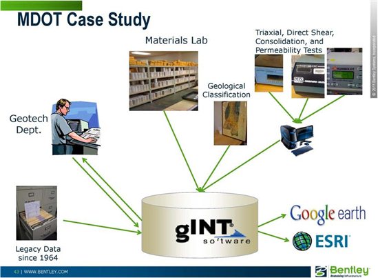
The Mississippi Department of Transportation Geotechnical Department has won the 2012 Be Inspired prize for Innovation in Geotechnical and Geoenvironmental Engineering with their implementation of gINT at Mississippi DOT – (Jackson, Mississippi, U.S.A.)

The win recognizes how Mississippi DOT used gINT to resolve data management issues.

A disjointed workflow for processing geotechnical field data in the geotechnical and materials departments had resulted in information being archived as Excel or PDF files with no search capabilities. Manual transfer of data between departmental reporting tools also introduced errors.

The Mississippi Department of Transportation implemented gINT to streamline the collection, processing, and storage of geotechnical data for use in boring log reports and GIS applications. The first phase of the project involved creating a geotechnical database structure, report templates, and a gINT subroutine to import existing spreadsheets.

Phase two expanded the database structure to accommodate triaxial test data and reports, and to import external lab data.

Be Inspired Special Recognition Awards winners for 2012 are listed at Be Inspired Winners.


2011's Be Inspired prize for Innovation in Geotechnical and Geoenvironmental Engineering prize was also won using gINT:

Jan de Nul NV in their $5.5 billion Expansion of the Panama Canal used gINT to store and analyze geological data, and then used MXROAD to build 3D models of the material profiles.

In 2010, the first year the Be Inspired prize for Innovation in Geotechnical and Geoenvironmental Engineering was awarded, a Be Inspired finalist in this category also used gINT:

Orion Engineering, Inc's Going to the Sun Road in Glacier National Park, Montana, USA, faced the task of stabilizing 30-foot-high retaining walls built in the 19th century. Using gINT to report the extensive subsurface investigation needed for the project, Orion developed an innovative micro-pile supported concrete road section design and avalanche modeling that can be applied to similar distressed areas.

Additional submissions from projects using gINT were included in Be Inspired publications in 2010:

Coffey Geotechnics' $2.8 million Eglinton Crosstown Light Rail Transit Investigation in Toronto, Ontario, Canada, was a showcase for a redesign of their gINT database as a component structure to standardize reporting of data, enhance data mining and filtering, and allow gINT to better use geotechnical data for calculations.

Structural Soils Ltd's Hinckley Point Onshore Site Investigation at Hinckley Point in the UK used gINT exclusively to collate and manage all site and lab data collected from over 5 million kilometers of rotary-drilled drill cores.

You can join this elite group - enter your own project or gINT innovation next year. We could be celebrating your win for 2013!

Bentley LEARNing Conference: Attend Sessions That Matter to You

$
0
0

It's less than a month away now: the Bentley LEARNing Conference. I wanted to share this cool video (by Shar Govindan in LEARNservices) on YouTube - it takes a snappy minute to highlight the more than 300 interactive lectures and hands-on workshops in nine session tracks!

Bentley LEARNing Conference is May 13-16 in Philadelphia, PA.

gINT Training Makes Local News in Doha (Qatar)

$
0
0

A recent course on using gINT Professional held in Doha in the State of Qatar was featured in the local Baladiya News, and posted online.

The inset photo shows Johhny Martel, a Bentley consultant, demonstrating the reporting process for subsurface data in gINT to the students.

gINT CIVIL TOOLS

$
0
0

Hello,

We are using Microstation V8i SS3 and Power inRoads SS2.  Have been trying-out gINTCivilTools inside Microstation, started from the key-in dialog.  After attaching cel library file and fill-out civil tools dialog such as project, setings, etc. and want to show boreholes in plan or profile, we get error "Error attaching cell library, cannot plot boreholes" 


Any ideas on how to get the Civil Tools to connect with the cel library?

gINT Can: Change Grid Data Entry Layout

$
0
0

Layout of tables, fields and records is easily changed in the Input application, to tailor the grid data-entry screen for easy input.

With a few restrictions, the order of fields can easily be changed by dragging the column header right or left. This does not affect reporting of data stored in the field, because gINT does not use field order to locate data.

Record order can also be changed by right-click-and-dragging the left-most cell in the row up or down:


You can change the order in which tables are displayed in the grid data-entry screen:

With these tools, it is easy to configure the data-entry grid for efficient input.

References - Help Topics
- For information on moving columns and rows, see gINT Help > Contents > Input Application Group > Grids
- Changing table display order is covered in gINT Help > Contents > Commands > Alphabetical List > Input Sequence.


Pat Cummings
gINT Trainer

gINT: Geotechnical Software for the way you work!

$
0
0

On December 8, 2011 Bentley hosted an eSeminar about gINT software titled "Geotechnical Software for the way you work!". It addressed new features of gINT v8i SS1 which was released December 9, 2011.

During this seminar, the latest tools enabling you to export boreholes as 3D cylinders in MicroStation, export DTMs based on gINT subsurface data to LandXML, and apply user-defined coordinate systems were introduced.

Throughout the eSeminar attendees were able to type in questions. As many as possible were addressed during the eSeminar. Due to time constraints, several questions were not addressed.

This post is a summary of the questions asked and their answers. A few questions were asked more than once in different ways. These questions were consolidated.

Also, a fair attempt to break the questions in to categories was made. Categories include: Modeling/CAD Environment, gINT Capabilities and Features, and Other.

Modeling/CAD Environment

1) Can cross sections be cut in the DGN file?

Answer: Yes. If you need a series of sections along a reference line or alignment, a Bentley civil package such as GEOPAK, InRoads or MXROAD will be required. If you are looking to create a single cross section through a particular section then you can use MicroStation's dynamic section capabilities.

2) Can you draw cross sections through the created XML surfaces

Answer: Yes

3) Is there any planned integration between the gINT software and the GEOPAK Geotechnical tools?

Answer: GEOPAK and gINT are both Bentley solutions. Integration and working together to create a better solution is a long-term objective. Currently gINT does export borehole data in to a format which can be imported in to GEOPAK and used with the Geotechnical Tools.

4) Can GEOPAK model slope failure?

Answer: No, GEOPAK does not model slope failure. However, Bentley is the third party reseller for GeoStructural Analysis which includes a slope failure evaluation module.

5) Is GEOPAK just a drawing product software or does it perform modeling/strength calculations too?

Answer: GEOPAK is a civil design modeling application widely used for transportation projects. It cannot perform engineering analyses.

6) Can we use InRoads instead of GEOPAK?

Answer: Yes

7) Will we be able to import a gINT database in to GEOPAK Geotechnical Tools?

Answer: There already exists an Export to GEOPAK feature in gINT such that the data exported is used by the GEOPAK Geotechnical Tools. gINT Help provides details to executing the export feature.

8) Can AutoCAD Civil 3D read the i-model DGN files and DTMs?

Answer: AutoCAD 3D cannot read the i-model DGN files. DTMs are XML files (that is, the "DTM to LANDXML" export function in gINT exports the files as XML files). These files can be read by any application that is capable of reading XML files.

9) Is there a way to view the boreholes in 3D using AutoCAD civil 3D or ArcGIS instead of MicroStation.

Answer: No. For AutoCAD and ArcGIS products only 2D views are possible after export of data from gINT.

10) Is there a plan to provide an export to AutoCAD in the near future?

Answer: There is a 2D AutoCAD export in gINT available at this time. gINT does also export reports to DXF format. For a 2D export to DXF format in gINT go to teh Output tab and select File => Export to File =>AutoCAD (DXF) File.

11) Will gINT be compatible with AutoCAD and perform similar features to those you've shown on MicroStation in the near future?

Answer: At this time the i-model features can only be read by Bentley products. LANDXML files are an industry standard which can be read by many applications.

12) Will a DXF exported database which is opened by AutoCAD be able to do volume calculations based on the lithology?

Answer: From gINT, DXF exports are limited to reports such as logs and fences. At this time data from the gINT database cannot be exported into DXF format to be read by and CAD application. Data can be exported from gINT v8i SS1 in XML format to be imported by CAD applications. With the current version of MicroStation (v8i SS2) all volume calculations are performed with a civil solution which overlays MicroStation such as GEOPAK, InRoads or MXROADS.

13) Is labeling of the 3D boreholes done in gINT or MicroStation?

Answer: gINT

14) Can the gINT labeling be edited in MicroStation?

Answer: The i-model is not able to be edited, including the labeling exported from gINT.

15) Can you upload a 3D model scan of the area where the soil borings were taken? In MicroStation you imported a 2D sitemap, could you upload a 3D terrain model?

Answer: Yes

16) We have MicroStation v8i Select Series 2. Will MicroStation v8i Select Series 2 still work with gINT v8i Select Series 1?

Answer: gINT v8i will continue to work with MicroStation v8i Select Series 2 as before. gINT v8i Select Series 1 has the enhanced capabilities of exporting i-models and Digital Terrain Models (DTMs). Referencing in the i-model can be done with MicroStation v8i SS2. Digital Terrain Model (DTM) work was performed with GEOPAK - a civil modeling overlay to MicroStation. MicroStation SS3 (anticipated release spring 2012) will be able to import DTMs without a civil engineering package such as GEOPAK or InRoads.

17) Is the scaling of the borehole width and length automatic when imported MicroStation on cross sections?

Answer: The scaling for the boreholes is automatic when imported in to MicroStation. gINT requires a field for the borehole radius, so you have control over the radius.

gINT Capabilities and Features

1) I don't have the specs for gINT, what is it generally? Is it a separate, stand alone software that works within  or outside MicroStation?

Answer: gINT is a standalone, geotechnical data management tool. Inside of gINT you can create several reports including borehole logs, fences, and graphs. gINT also exports and imports all geotechnical data which enables it to work with other software applications such as MicroStation, GEOPAK and Excel, for advances analysis and design. For additional information about gINT please refer to the gINT webpage.

2) Not related to the presentation topics, but is there a way to input pile load test data into gINT?

Answer: At this time gINT does not include a standard template for pile data. However, you can add one if you like, Bentley Professional Services can also assist you with development. gINT does not typically analyze pile data at this time - it would only store your geotechnical data in a single location for you. As an aside, Bentley has another application, GeoStructural Analysis, which has a pile analysis module.

3) Do I understand that if one types in the latitude and longitude, gINT will calculate the northing and easting?

Answer: Yes, this coordinate conversion occurs within the gINT Professional Plus product.

4) What are the possibilities in gINT to have environmental lab results and display them in a customized table/sheet?

Answer:gINT is a fully customizable database. It is possible to add tables for Environmental lab results and display them on customized tables/sheets.

5) Can gINT also model groundwater data from boreholes?

Answer: gINT can produce depth over time plots for groundwater measurements. Also, groundwater elevations recorded can be plotted on a fence or log. However, groundwater profiles cannot be created in gINT.

6) We are using two versions of gINT: v8 and v8i. Will these o-model and DTM to XML features work with both versions of gINT or just v8i?

Answer: These features are available in gINT v8i SS1, which was released on December 9, 2011.

7) What type of database is gINT using?

Answer: gINT Logs and gINT Professional use a Microsoft Access database. gINT Professional Plus uses a SQL server database.

8) How do you plot borehole information on a profile?

Answer: You can plot borehole information in a profile format using gINT fences. If you want to plot along a roadway alignment, then you can use GEOPAK or InRoads, or you can use the alignment option in gINT to define a specific alignment and create a profile along the alignment.

9) We are using gINT 08.30.02.39, and we are a Bentley Select ELS customer. Is the version available tomorrow (December 9, 2011) available to me with no additional cost?

Answer: If you are a current Bentley Select ELS customer or you have a current Bentley Select agreement then you can download the new version of gINT at no additional fee until your Select agreement lapses.

10) Will gINT be integrated with ProjectWise and MicroStation in SS3?

Answer: Beginning with gINT v8i (released in May, 2011) gINT had ProjectWise capabilities. The December 9, 2011 release of gINT (v8i SS1) is increasing the ability of gINT to work with MicroStation. Integration and working together to create a better solution is a long-term objective for Bentley applications.

11) Can the database be manipulated to create rockline information only and how difficult is it to bring this information into InRoads?

Answer: Yes, just the rockline information can be created. gINT has a direct export for InRoads The gINT help menu has specific directions on how to create the necessary correspondence file and step-by-step directions.

12) How does the gINT export feature deal with boreholes where certain strata are absent?

Answer: gINT uses the same, standard linear interpolation of a TIN (Triangulated Irregular Network) used in many civil applications including GEOPAK, InRoads and MXROAD. It is up to the user to refine TIN networks as they see applicable.

13) If the rockline created is close to the OG surface it sometimes can triangulate over teh OG. Then the rock DTM has to be modified to force the rockline below OG. This is necessary so that the rockline shows properly within InRoads cross sections for quantity purposes. Does gINT automatically fix rockline that may deviate above the OG surface?

Answer: No - gINT does not automatically fix the triangulated surface. gINT uses the standard linear interpolation of a TIN. The user may decide when to refine the TIN network.

14) How does the gINT DTM export feature deal with boreholes where certain strata are absent (3D modeling)?

Answer: gINT uses the straight line interpolation to develop TIN based on DTMs. The user may modify the TINS as necessary.

15) Would we need our geotech consultants to provide data in a specific format to be imported into gINT software?

Answer: gINT can import data in CSV and Excel formats, and Microsoft Access. However, unless the structures match your defined gINT structure, a correspondence file is necessary to import the data, and sometimes not all data is a complete fit. It is best to request that consultants use a provided format be it a gINT database and library or and Excel worksheet with a structure created by exporting your gINT database structure to Excel.

16) When exporting the XML, what happens when the borehole has the same material type listed twice?

Answer: gINT requires that graphic symbols be unique. If there are two identical graphic symbols in a single borehole, then one of them must be renamed (to the same thing for all boreholes with that second layer): for example, if you have two SAND graphics in a borehole, rename the second, deeper graphic in all the boreholes SAND2. Export each DTM. Open the second DTM export and perform a query to change all SAND2 graphics to SAND. You can now import each layer in to a separate DTM.

17) Please explain the scale factor in gINT.

Answer: gINT works in paper space. So, when exporting a sitemap, fence or log out of gINT you must multiply it by a factor of 12 to put it in real world space.

18) Can you import the geotech data from and Excel file in to gINT.

Answer: Yes, you can import geotechnical data in to gINT from an Excel file. If the structure is not identical to your gINT database you may require a correspondence file. Go to gINT's Help menu for additional information.

19) Did we understand correctly that elevations of the boreholes are not stored in the overall database?

Answer: Borehole elevations are stored in the gINT database.

20) Does gINT have the possibility to show boreholes on a 2D map with colored boreholes according to a property in the gINT database?

Answer: Yes. gINT can show boreholes on fence diagrams and can also show borehole locations on a 2D sitemap. You can show graphics and color on the boreholes in the fence developed in gINT.

21) Can the input and output screens be customized in gINT? And can that be done by the user, or does Bentley need to do that?

Answer: gINT is a completely flexible database management system. The data entry user interface (database) and reports can be customized by users can request the Bentley Professional Services team to perform modifications to the database or reports.

Other

1) You stated to go to the on-demand seminar link for more eSeminars but will there be a separate folder for gINT?

Answer: The link given (found here) directs you to seminars specifically for gINT.  eSeminars for all Bentley products can be found at http:/www.bentley.com/en-US/Corporate/Events/OnDemand/">http://www.bentley.com/en-US/Corporate/Events/OnDemand/.

2) How does gINT work with exchanging data to ArcGIS?

Answer: gINT professional and gINT Professional Plus can be linked directly with ArcGIS. Please contact your Bentley representative for additional details.


2012 Be Inspired Innovation WON AGAIN with gINT

$
0
0

The Mississippi Department of Transportation Geotechnical Department has won the 2012 Be Inspired prize for Innovation in Geotechnical and Geoenvironmental Engineering with their implementation of gINT at Mississippi DOT – (Jackson, Mississippi, U.S.A.)

The win recognizes how Mississippi DOT used gINT to resolve data management issues.

A disjointed workflow for processing geotechnical field data in the geotechnical and materials departments had resulted in information being archived as Excel or PDF files with no search capabilities. Manual transfer of data between departmental reporting tools also introduced errors.

The Mississippi Department of Transportation implemented gINT to streamline the collection, processing, and storage of geotechnical data for use in boring log reports and GIS applications. The first phase of the project involved creating a geotechnical database structure, report templates, and a gINT subroutine to import existing spreadsheets.

Phase two expanded the database structure to accommodate triaxial test data and reports, and to import external lab data.

Be Inspired Special Recognition Awards winners for 2012 are listed at Be Inspired Winners.


2011's Be Inspired prize for Innovation in Geotechnical and Geoenvironmental Engineering prize was also won using gINT:

Jan de Nul NV in their $5.5 billion Expansion of the Panama Canal used gINT to store and analyze geological data, and then used MXROAD to build 3D models of the material profiles.

In 2010, the first year the Be Inspired prize for Innovation in Geotechnical and Geoenvironmental Engineering was awarded, a Be Inspired finalist in this category also used gINT:

Orion Engineering, Inc's Going to the Sun Road in Glacier National Park, Montana, USA, faced the task of stabilizing 30-foot-high retaining walls built in the 19th century. Using gINT to report the extensive subsurface investigation needed for the project, Orion developed an innovative micro-pile supported concrete road section design and avalanche modeling that can be applied to similar distressed areas.

Additional submissions from projects using gINT were included in Be Inspired publications in 2010:

Coffey Geotechnics' $2.8 million Eglinton Crosstown Light Rail Transit Investigation in Toronto, Ontario, Canada, was a showcase for a redesign of their gINT database as a component structure to standardize reporting of data, enhance data mining and filtering, and allow gINT to better use geotechnical data for calculations.

Structural Soils Ltd's Hinckley Point Onshore Site Investigation at Hinckley Point in the UK used gINT exclusively to collate and manage all site and lab data collected from over 5 million kilometers of rotary-drilled drill cores.

You can join this elite group - enter your own project or gINT innovation next year. We could be celebrating your win for 2013!

Bentley LEARNing Conference: Attend Sessions That Matter to You

$
0
0

It's less than a month away now: the Bentley LEARNing Conference. I wanted to share this cool video (by Shar Govindan in LEARNservices) on YouTube - it takes a snappy minute to highlight the more than 300 interactive lectures and hands-on workshops in nine session tracks!

Bentley LEARNing Conference is May 13-16 in Philadelphia, PA.

gINT Training Makes Local News in Doha (Qatar)

$
0
0

A recent course on using gINT Professional held in Doha in the State of Qatar was featured in the local Baladiya News, and posted online.

The inset photo shows Johhny Martel, a Bentley consultant, demonstrating the reporting process for subsurface data in gINT to the students.

gINT Ss2 08.30.04.206 is now available.

$
0
0

We are pleased to announce the release of gINT V8i SELECTseries 2 (08.30.04.206). It is now available for downloading from SELECTservices: http://appsnet.bentley.com/myselectcd/. The performance of SQL databases (gINT Professional Plus) have been improved significantly.

gINT V8i Ss2 08.30.04.206 New Features

2 new gINT Rules samples

$
0
0

We have added two new gINT Rules samples available for free from http://communities.bentley.com/products/geotechnical1/w/wiki/3951.gint-rules-samples.aspx.   

gr022

Automatically assigns a unique lab number to every new test specimen on saving the specimen table. These numbers are unique across projects, as long as all users are using the same library. The previous maximum number is stored in a library table and there is code in the rule to prevent two users accessing the library table at the same time. This is done by inserting an impossible last maximum number (-1) in the library table and inserting the new maximum when the save is completed. Further, this code waits a prescribed amount of time if a conflict is found to allow the table to become available. If the table does not become free in that time, a message is shown to try saving later or to undo the changes and to fix the problem (instructions given in the message).

gra015

Inserts alignment Z values from surfaces. Can select as many alignments and surfaces as desired. Each surface is associated with a specific Z column (specified by the user). In addition, additional alignment points can be inserted by specifying a station increment for calculation of the Z values in addition to the calculation at existing alignment points.

If a point on the alignment has coordinates outside of a surface, the program will clear the Z value at that record and give a message at the end of the running of the code with all such records.

This add-in can be run from any table while in Input. You do not have to be in the alignment tables.

You can see the Z profile lines on your fence reports by selecting one of the alignments whose Z values were populated at output time.

This process has two purposes:   1. By storing the Z values with the alignments once, the output can be significantly faster than specifying the surfaces at output time.   2. The alignment data with the calculated Z values can be exported to Excel or CSV for use with other programs.

The downside of this process is that if the surfaces change, you must re-run this add-in to obtain the updated values. Note that you do not have to erase the previous data. The program will overwrite them.

See Also

gINT Rules Code Manual

Article on how Abu Dhabi City uses gINT for managing information for over 20,000 boreholes


Up coming gINT classes

$
0
0

For new gINT users or for those who would like to brush up on gINT, here is a list of upcoming classes taught in a virtual classroom, online, for gINT:


Course


Start Date

End Date


Daily

Start Time

End Time


Time Zone


Total

Length


gINT Fundamentals (Imperial)

22 Jul 2014
23 Jul 2014

10:30 AM
  5:00 PM

EDT

12 hrs.


gINT for Administrators

18 Aug 2014

19 Aug 2014

10:30 AM

5:00 PM

EDT

12 hrs.


gINT Fundamentals (Imperial)

15 Sep 2014
16 Sep 2014

10:30 AM
  5:00 PM

EDT

12 hrs.


gINT for Administrators

14 Oct 2014

15 Oct 2014

10:30 AM

5:00 PM

EDT

12 hrs.


gINT Fundamentals (Imperial)

03 Nov 2014

04 Nov 2014

10:30 AM
  5:00 PM

EDT

12 hrs.


gINT Fundamentals (Imperial)

15 Dec 2014

16 Dec 2014

10:30 AM

5:00 PM

EDT

12 hrs.


Please sign up via Bentley Institute’s LEARNserver. Note the Time zones before signing up.


For companies that have more than a couple of users to train, on site classes or virtual one customer classes could be arranged. Contact your Bentley Account Manager or Sales Associate for details.

New gINT Release 08.30.04.220

gINT Webinar: "Subsurface Asset Management: What Lies Beneath"

$
0
0

Do you want to learn how to improve the management and reporting of your subsurface information?

In this informative session on gINT geotechnical software, we'll demonstrate how gINT has helped users integrate their project delivery, improve their return on investment and leverage the valuable geotechnical data across multiple projects.

Subsurface investigations are essential for virtually all civil, mining and infrastructure projects: roads, bridges, railways, and structures of all types. This data is necessary for the verification and design of foundations, slopes, retaining walls, tunnels, roads, rail and more. Access to this information is crucial for remediating potentially hazardous underground materials in order to preserve our environment.

Bentley’s gINT software provides centralized data management and reporting for subsurface projects of all types. Users can streamline processes with accessible, interoperable data and enhanced subsurface reporting. Increase your productivity with supporting engineering knowledge and judgment.

Please join us for this webinar that will feature a product demo and practical discussions on how you could be working smarter and saving more money with every subsurface project.  

Gary Logan, EMEA Sales Executive, will be presenting 3 sessions:

Wednesday, September 17, 2014 at 18:00 UTC: http://pages.info.bentley.com/event-details-ae/?webinar=CO_ESEMB_GINT_091714&eventGUID=bed8478f-5817-4735-96cc-470d112caf27

Wednesday, September 24, 2014 at 10:00 UTC: http://pages.info.bentley.com/event-details-ae/?webinar=CO_ESEMB_GINT_092414&eventGUID=cea2d734-05a1-46a3-be10-10bf226d85c9

Thursday, September 25, 2014 at 5:00 UTC: http://pages.info.bentley.com/event-details-ae/?webinar=CO_ESEMB_GINT_092514&eventGUID=77b6193c-e389-4aee-9275-9ab35c17b8e0

(The times shown on the above pages will be correct for your time zone.)

New gINT build 08.30.04.242 is now available

GSA Version 19 Coming Soon

$
0
0

Bentley is the exclusive third party reseller for GSA in North America. The developer is releasing version 19 in mid-November. FINE (the developer) performs all testing and certification of calculations before the release. Once we obtain the files, we will test them internally for download and installation.  If all is well, we should have the new version available within a few of weeks after the initial release.

A few new exciting details with regards to Version 19 include:  

-The connection of walls modules with the Piles and Pile Group modules

-In Pile Group, the ability to specify a general shape for pile caps and general coordinates of piles

-In MSE wall - internal stability for walls with benches

Stay tuned for additional news regarding GSA, especially the release of version 19.

Viewing all 135 articles
Browse latest View live


<script src="https://jsc.adskeeper.com/r/s/rssing.com.1596347.js" async> </script>